Welcome to our project newsletter! We’re excited to share insights into the detailed planning and engineering behind the Andiracha-Geyi Road Project. This vital infrastructure aims to enhance connectivity, boost socio-economic development, and improve access to essential services for the communities in the region. This newsletter dives into the core components of the project: from understanding the land to designing the structures and estimating the costs.
Engineering the Path Forward
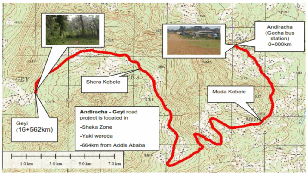
The Andiracha-Geyi Road Project, spanning approximately 16.56 km, is a crucial development initiative in the Southern Nations, Nationalities, and Peoples’ Region (SNNPR) of Ethiopia.
Project Location:
The project is specifically situated in the Sidama Zone, within the Andiracha Wereda. It commences at the outskirts of Andiracha town (also referred to as Gech town or Size town) and extends to Geyi Kebele. The starting point is approximately 664 km southwest of Addis Ababa and about 50 km from Tepi town. The road is designed to connect Geyi, Shere, and Moda kebeles to Andiracha.
This new gravel road is being constructed to a DC4 unpaved standard with a 7m carriageway width.
Key Objectives & Scope:
- Enhanced Connectivity: To provide reliable road access, which is currently limited, particularly in challenging terrains.
- Socio-Economic Boost: To facilitate easier market access for agricultural products and modern inputs, thereby uplifting the local economy.
- Detailed Design: The consultancy services involved comprehensive studies, including field and laboratory investigations, environmental and social impact assessments, detailed engineering design, and the preparation of complete drawings and cost estimates.
- Quality Standards: The project adheres to the Ethiopian Roads Authority (ERA) and other applicable standard specifications, ensuring quality control throughout the construction.
The project involves significant earthworks, the construction of new drainage systems and structures, and ancillary works such as quarry site development.
Navigating the Landscape: Topography Insights
Understanding the terrain is fundamental to effective road design. The Andiracha-Geyi project route presented a diverse and challenging topographical profile.
Survey & Findings:
- Comprehensive Surveying: Detailed topographic surveys were conducted using advanced GPS and Total Station equipment. This included establishing horizontal and vertical control points tied to the National Grid, benchmark establishment, and detailed cross-section surveys at 20m intervals (and closer on curves) with a corridor width of 50-100m in rural areas.
- Terrain Classification: The road traverses a mix of terrains:
- Rolling Terrain: Approximately 3.6 km (21.74%)
- Mountainous Terrain: Approximately 7.4 km (44.68%)
- Escarpment: Approximately 1.2 km (7.25%)
- Village/Kebele Areas: Approximately 4.363 km (26.34%)
- Design Implications: The varied terrain, especially the mountainous and escarpment sections, necessitated careful geometric design, including considerations for design speed, horizontal and vertical alignments, and switchback curves in very steep areas to ensure safety and drivability. Digital Terrain Models (DTMs) were crucial in this process.
Managing Water & Building Resilience: Hydrology and Structures
Effective water management is critical for the longevity and stability of any road, especially in areas with significant rainfall. The Andiracha-Geyi project area receives an average annual rainfall of 1800-2200 mm.
Hydrological Analysis & Structural Design:
- Peak Discharge Estimation: Hydrological studies were undertaken to compute peak discharges for all watercourses crossing the road. Methodologies like the Rational Method and the U.S. Soil Conservation Services (SCS) method were employed, considering catchment area delineation, rainfall intensity, and runoff coefficients.
- Drainage Structures:
- Minor Structures: A significant number of new minor drainage structures are proposed, including Reinforced Concrete (RC) pipe culverts (typically 48″ diameter) and single/multiple span Slab or Box Culverts (2m – 6m). The design considered inlet/outlet control and appropriate headwater levels.
- Existing Structures: The few existing structures, like an arch masonry culvert, were found to be in poor condition (e.g., blocked by silt) and are generally proposed for replacement.
- No Major Bridges: The route does not necessitate new major bridge structures (span > 6.0m).
- Design Considerations: The design of drainage structures aimed to safely evacuate design floods without causing damage to the embankment or the surrounding environment, adhering to the ERA Low Volume Drainage Design Manual. This included determining appropriate waterway openings and freeboard.
The Groundwork: Materials Investigation
A thorough investigation of soil and construction materials is essential for designing a durable and cost-effective pavement structure.
Key Findings:
- Subgrade Investigation:
- Field Work: Conducted Dynamic Cone Penetrometer (DCP) tests and trial pit explorations along the alignment to assess in-situ subgrade strength (CBR values).
- Soil Types: The predominant subgrade material is fine-grained, with clayey silt and silty clay soils encountered. Some sections exhibited potentially expansive soils with high plasticity (Liquid Limit 33-68%, Plasticity Index 6-20%) and CBR swell values sometimes exceeding 3%.
- Problematic Soils: Stretches with problematic expansive soils (e.g., from Km 4+113 to 16+152) were identified. Recommendations include excavation up to 60cm and replacement with suitable selected material (PI<30, LL<60, CBR ≥5%, swell <2%).
- Design Subgrade Strength: After considering treatment for unsuitable sections, a design CBR of 5.8% (S3 subgrade class) was determined for pavement design.
- Construction Material Sourcing:
- Gravel Borrow Areas: Three potential borrow areas were identified. Tests indicated that some sources are suitable for capping layers, road base, and wearing courses, while others are suitable as general borrow material.
- Rock Quarry Sources: Two quarry sources (basaltic rock) were identified. One source (at 0+000, LHS 5km) was found qualified for crushed aggregate, masonry, and rock fill.
- Sand Sources: A scarcity of natural sand sources was noted in the immediate vicinity. The use of crusher-run sand (from the qualified rock quarry) is recommended for concrete and masonry works.
- Water Sources: River water sources were identified (e.g., at Km 4+065 and Km 10+147) and tested to be suitable for construction purposes.
Counting the Cost: Project Estimate
A detailed cost estimate provides the financial blueprint for the project’s execution. The Engineering Cost Estimate for the Andiracha-Geyi Road Project (Km 0+000 to Km 16+563) has been meticulously prepared.
Summary of Costs:
- Total Estimated Cost (Grand Total including VAT & Contingencies): Approximately 403.6 Million Ethiopian Birr.
- Breakdown by Major Work Categories ( indicative, before contingencies & VAT):
- Site Clearance: ~3.36 Million Birr
- Drainage: ~109.03 Million Birr
- Earthworks: ~149.29 Million Birr
- Road Base and Gravel Wearing Course: ~13.81 Million Birr
- Structures: ~16.82 Million Birr
- Ancillary Works: ~9.53 Million Birr
- Day Works: ~17.24 Million Birr
- Cost per Kilometer: Approximately 24.37 Million Birr/Km.
The estimate is derived from applying current market prices for materials, equipment rental rates, and manpower costs to the bill of quantities. It includes considerations for overhead costs, profit margins, and provisions for price escalation and contingencies (10% physical contingency).
Note: Additional costs such as supervision, land acquisition compensation, and utility relocation are also applicable but may be budgeted separately by the Contracting Authority.
Looking Ahead
The Andiracha-Geyi Road Project represents a significant investment in the future of the region. The detailed engineering design, material sourcing, and cost estimations have laid a solid foundation for the successful construction of this crucial roadway.
Stay tuned for more updates as the project progresses!