Welcome to our project newsletter! We’re excited to share key insights and progress updates on the Shewa-Bench-Mazi Road Project, a vital infrastructure development aimed at enhancing connectivity and fostering socio-economic growth in the Southern Nations, Nationalities, and Peoples’ Region (SNNPR) of Ethiopia.
Project Location
- The Shewa-Bench-Mazi Road project is strategically situated in the SNNPR. Key location details include:
- Region/Zone: Southern Nations, Nationalities, and Peoples’ Region, Bench Maji Zone.
- Wereda: The project falls within Shey Bench Wereda.
- Route: The 11.8 km road starts at the outskirts of Shey Bench Wereda in Siz town (often referred to as Siz Junction or Shewa Bench/Mazi Junction at km 0+000) and extends to Mazi Kebele (ending at km 11+800).
- Connectivity: The starting point is approximately 585 km southwest of Addis Ababa and about 57 km from Mizan (the zonal town). It’s also located around 27 km from the Wacha Maji Junction on the Bonga-Mizan Road.
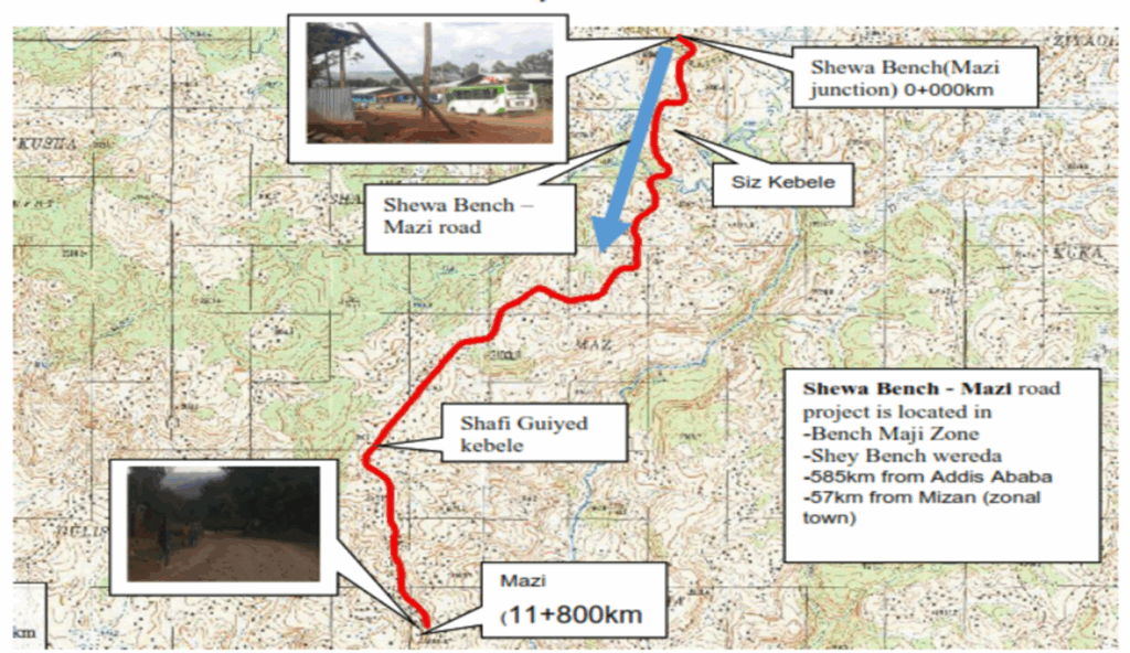
- This road, designed to a DC4 unpaved standard with a 7-meter wide carriageway, is set to significantly improve local transportation.
- Let’s walk through the core components of this important undertaking:
Understanding the Land: Topography
- The first step in any road project is a thorough understanding of the land it will traverse. The Shewa-Bench-Mazi route presents a diverse topographical profile:
- Terrain Mix: The alignment navigates through rolling terrain (accounting for 54% of the length), mountainous sections (14%), and town areas (32%).
- Detailed Surveys: Comprehensive topographic surveys were crucial. Using advanced GPS technology and Total Stations, our teams established precise horizontal and vertical control points tied to the National Survey Grid. This allowed for the creation of an accurate Digital Terrain Model (DTM), which forms the foundation for all subsequent design work, ensuring the road is optimally aligned with the natural contours of the land.
Managing Water: Hydrology and Structures
- Effective water management is critical for the longevity and safety of the road. Our approach includes:
- Hydrological Analysis: In-depth studies were conducted to understand rainfall patterns and catchment areas. Methodologies like the Rational Formula and the U.S. Soil Conservation Service (SCS) method were employed to estimate design flood discharges for various return periods.
- Major River Crossing: A significant new bridge is designed for the BINI River, located at approximately km 2+105.
- Design: This will be a single-span, 14-meter long bridge with a clear height of 4.2 meters.
- Capacity: It’s engineered to safely pass a 50-year flood event, with a design discharge of 193.33 cubic meters per second (m³/s). The existing bridge at this location will be replaced due to its age and condition.
- Foundation: Site investigations confirmed suitable foundation conditions with an allowable bearing capacity of 500 kPa.
- Minor Drainage Solutions: To manage smaller watercourses and ensure proper drainage along the route, sixteen (16) new reinforced concrete pipe culverts, each with a diameter of 1219mm (48 inches), will be installed. These are designed to handle localized runoff effectively.
Sourcing the Right Components: Material Investigations
- The quality and availability of construction materials are key to a successful build. Extensive investigations were carried out:
- Subgrade Soils: The natural soil along the alignment is predominantly fine-grained (clay silts). Detailed testing, including Dynamic Cone Penetrometer (DCP) tests and laboratory analysis (CBR, Atterberg limits), characterized these soils.
- Problematic Soils: Approximately 7.5 km of the initial road stretch was identified as having problematic expansive soils. These areas will require special treatment, involving excavation of the existing material to a depth of 60cm and replacement with suitable, selected fill material (CBR ≥ 5%, low swell potential).
- Design Strength: The overall design subgrade strength is classified as S3 (CBR 5-7%).
- Borrow Materials: Two suitable gravel borrow areas have been identified, providing ample material for sub-base layers, capping (a protective layer below the sub-base), and general fill.
- Rock Quarries: Two quarry sites have been confirmed, yielding good quality basaltic rock. This rock will be processed for crushed aggregates (used in pavement layers) and for masonry work in structures.
- Sand: Natural sand sources are scarce in the immediate project vicinity. Therefore, crusher-run sand, a by-product of rock crushing operations at the quarry, is recommended for use in concrete and mortar.
- Water: Sufficient water sources for construction activities (compaction, concrete mixing) have been located near the project area.
Designing for Durability and Safety: Engineering Aspects
- The engineering design focuses on creating a durable, safe, and cost-effective road:
- Design Standards: The road is designed in accordance with the Ethiopian Roads Authority’s (ERA) Low Volume Roads Design Manual for a DC4 unpaved standard.
- Geometric Design: The road’s alignment, curves, and gradients are carefully designed to match the terrain and designated design speeds. These speeds vary: 70 km/h for flat sections, 60 km/h for rolling terrain, 50 km/h for mountainous areas and populated town sections, and 25 km/h for escarpment sections.
- Pavement Structure: The pavement is designed for a 10-year service life, considering the expected traffic (LV-5 traffic class). The structure will consist of:
- A 150mm thick gravel wearing course (the top driving surface).
- A 200mm thick road base layer.
- A 150mm thick capping layer to protect the subgrade.
- Road Safety: Safety is a paramount concern. The design incorporates appropriate road signage, and specific considerations for pedestrian safety will be implemented in town sections and other populated areas.
Project Cost Estimate
Project Estimate A detailed cost estimation has been prepared for the project:
- Total Project Cost: The estimated total cost for the construction of the 11.8 km Shewa-Bench-Mazi road is approximately 217 Million Ethiopian Birr.
- Cost per Kilometer: This breaks down to an average cost of around 18.39 Million Ethiopian Birr per kilometer.
- Inclusions: This comprehensive estimate covers all major activities, including site clearance, earthworks, drainage systems (culverts and the bridge), pavement layers, ancillary works, and a provision for contingencies.
- We believe the Shewa-Bench-Mazi Road Project will be a significant step forward for the region, improving access to markets, social services, and overall quality of life. We will continue to provide updates as the project progresses.