Welcome to our project update newsletter! We’re excited to share key insights from the detailed engineering design and cost estimation for the Lot-11 Shosha-Goma Road Project. This vital infrastructure aims to enhance connectivity and support socio-economic development in the region
Project Overview & Engineering Design
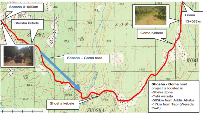
- The Shosha-Goma Road Project involves the design and construction of approximately 13.56 kilometers of new gravel road.
Project Location: - Region: Southern Nations, Nationalities, and People’s Regional State (SNNPR), Ethiopia.
- Zone: Sheka Zone.
- Wereda: Yeki Wereda.
- Specifics: The project route commences approximately 17km from Tepi town (the main town of Yeki Wereda) along the Tepi-Shishinda Road and terminates at Goma Kebele. The starting point is roughly 585km southwest of Addis Ababa. Currently, the road will serve as local access, ending at Goma Kebele without connecting to another existing road.
Key Engineering Highlights:
- Road Standard: The road is designed to DC4 unpaved standard as per the Ethiopian Roads Authority (ERA) Low Volume Roads Manual, featuring a 7-meter carriageway width.
- Design Speeds: To ensure safety and efficiency, design speeds are tailored to the varied terrain:
- Flat sections: 70 km/h
- Rolling sections: 60 km/h
- Mountainous sections: 50 km/h
- Escarpment sections: 25 km/h
- Populated areas: 50 km/h
- Pavement Design: A robust pavement structure is planned for a design life of 10 years, catering to a Traffic Class LV-5 (0.5-1.0 million Equivalent Standard Axles – ESAs) and a Subgrade Class S3 (CBR 5-7%). The typical pavement structure will consist of:
- Wearing Course: 200mm of G30 gravel material.
- Road Base: 200mm of G30 gravel material.
- Crossfall: A standard crossfall of 6% is designed for effective surface water drainage, which can be reduced to 4% in specific conditions (e.g., poor gravel quality, low rainfall areas).
Understanding the Ground: Topography & Materials
- A thorough investigation of the project area’s topography and material sources was crucial for a sound design.
Topographical Insights: - The road primarily traverses rolling terrain, with some stretches classified as mountainous.
- The dominant land use along the corridor includes densely populated trees, broadleaved forests, and evergreen lands, with some cultivated areas.
- Detailed topographic surveys, including GPS control points and cross-sections, have created an accurate Digital Terrain Model (DTM) for precise design work.
Materials Investigation Summary: - Subgrade Soils: The in-situ subgrade is predominantly fine-grained clay silt. While the design subgrade strength is classified as S3 (CBR 5%), extensive stretches have been identified as problematic (potentially expansive or low bearing capacity). These areas, spanning the entire alignment from Km 0+000 to Km 13+563, will require excavation to a depth of 60cm and replacement with suitable selected material (CBR ≥5%, PI<30, LL<60, Swell<2%).
- Gravel Sources: Two potential borrow pits have been identified:
- BP1 (Km 0+000): Suitable for capping layer or general fill (CBR 22%).
- BP2 (Km 5+000): Suitable for wearing course and road base (CBR 48.2%), though it may require blending to meet plasticity requirements.
- Rock Quarry: One basaltic rock quarry (Q1 at Km 0+600) has been identified, estimated to yield 25,000 m³. This source is deemed suitable for crushed aggregates, masonry work, and rock fill.
- Sand: Natural sand sources are scarce in the project vicinity. It is recommended to use crusher-run sand produced from the identified rock quarry for concrete and masonry works.
- Water Sources: Two reliable water sources have been identified at Km 0+000 and Km 5+590 (Beko River), both tested and found suitable for construction purposes.
Managing Water: Hydrology & Structures
- Effective drainage is paramount for the longevity and performance of the road.
Hydrological Approach: - Peak flood discharges for all watercourses crossing the road have been estimated using the Modified Rational Method (MRM) and the U.S. Soil Conservation Service (SCS) graphical method.
- Design storm return periods vary based on the type and size of drainage structures, adhering to ERA Low Volume Road standards for a DC4 road (e.g., 15-25 years for culverts, 25-50 years for bridges).
Drainage Structures: - Major Structure: One major bridge is proposed to cross the Beko River at Km 5+590. This will be a single-span bridge with a clear span of 16.0 meters and a clear height of 3.9 meters. The foundation will be on silty clay with cobbles/gravel, designed for an allowable bearing capacity of 430 kPa.
- Minor Structures: Numerous minor drainage structures are planned:
- 8 Box/Slab Culverts: With spans ranging from 2.0m x 2.0m to 4.0m x 2.1m.
- 17 Corrugated Metal Pipe (CMP) Culverts: Primarily 48-inch (1219mm) diameter pipes, some with multiple barrels.
- These structures are designed to safely convey water across the roadway, preventing erosion and damage to the road embankment and surrounding environment.
Project Investment
Cost Estimate A detailed cost estimate has been prepared to ensure financial planning and resource allocation.
Costing Methodology:
- The estimate is based on applying current market prices to the Bill of Quantities (BoQ) for all work items.
- This includes costs for materials, equipment rental, and manpower.
- An allowance of 35% covers site and head office overheads, profit margin, profit tax, and a provision for price escalation.
- A 10% contingency on construction costs is included.
Overall Project Cost: - Grand Total Estimated Cost (including VAT): 325.8 Million Ethiopian Birr
- Estimated Cost Per Kilometer: 24.02 Million Ethiopian Birr
- Key Cost Components (Breakdown of Total Construction Cost before contingencies & VAT):
- Earthworks: ~122.0 Million ETB
- Drainage: ~71.5 Million ETB
- Structures (Bridge & Culverts): ~18.1 Million ETB
- Road Base and Gravel Wearing Course: ~18.0 Million ETB
- Site Clearance: ~3.1 Million ETB
- Ancillary Works: ~7.6 Million ETB
- Day Works: ~17.2 Million ETB
- Additional costs for supervision, land acquisition, compensation, and utility relocation will also be factored into the overall project budget.
Moving Forward
The Shosha-Goma Road Project represents a significant investment in improving rural infrastructure. The detailed engineering studies have laid a solid foundation for its successful implementation, addressing topographical challenges, material sourcing, hydrological risks, and structural requirements.
Stay tuned for more updates as the project progresses!