Bringing Connectivity and Economic Growth to the Region
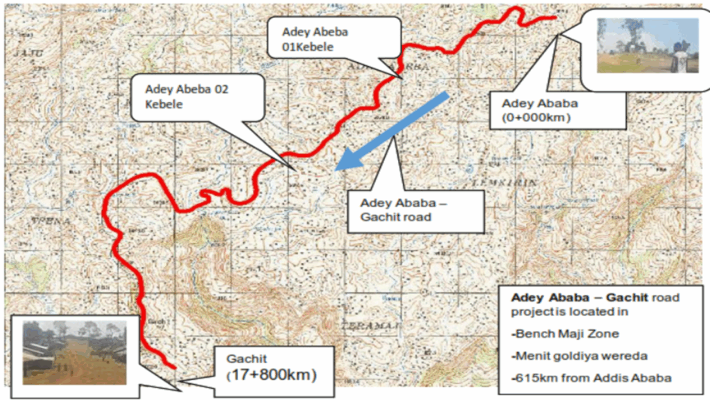
We’re excited to share an overview of the Adey Abeba-Gachit Road Project, a significant infrastructure development aimed at enhancing transportation and fostering socio-economic progress. The project is located in the Bench Maji Zone of the Southern Nations, Nationalities, and Peoples’ Region (SNNPR) of Ethiopia, specifically within the Menit Goldiya Woreda. The road starts at the outskirts of Bachuma town, approximately 615 km southwest of Addis Ababa, and will connect to Gachit Kebele. This newsletter delves into the key technical aspects of the project, offering insights into the meticulous planning and engineering involved.
Understanding the Landscape: Topography
- The Adey Abeba-Gachit road, stretching approximately 17.431 km, traverses a diverse and challenging landscape. The terrain is a mix of:
- Rolling Terrain: Accounting for about 4.35 km (24.96%)
- Mountainous Terrain: Making up the majority with approximately 9.55 km (54.79%)
- Town Sections: Covering roughly 3.53 km (20.26%)
- The initial topographical surveys established crucial horizontal and vertical control points tied to the National Grid. This involved:
- Establishing primary GPS control points at 3-5 km intervals.
- Installing permanent secondary control points (benchmarks) at a maximum of 500m intervals.
- Detailed cross-section surveys were conducted every 20m, with a corridor width of 50-100m in rural areas and 40m in urban areas, to create an accurate Digital Terrain Model (DTM) essential for the design.
- The road’s alignment predominantly follows an existing gravel path but includes necessary modifications and realignments to meet DC4 unpaved road standards, featuring a 7m carriageway width. The climate of the project area is primarily ‘Weyna Dega,’ with significant annual rainfall influencing design considerations.
Managing Water: Hydrology and Structures
Effective water management is critical given the region’s rainfall and terrain. The hydrological and hydraulic analysis focused on
- Rainfall-Runoff Models: Utilizing methods like the Rational Method and the SCS (Soil Conservation Service) method to estimate flood magnitudes for various return periods (e.g., 10-year for minor culverts, 50-year for major structures, and 100-year for bridge checks).
- Catchment Area Delineation: Using DEM data and GIS software to define watershed characteristics for designing drainage structures.
- Drainage Structures:
- Major Structures: One significant new bridge is proposed at Km 10+408 over the Dale River, with a clear span of 16m and a clear height of 3m. The foundation for this bridge is on rock, with an allowable bearing capacity of 2800 kPa.
- Minor Structures: Numerous new RC pipe culverts (mostly 48-inch diameter) are planned to replace existing inadequate structures and manage cross-drainage along the route. Twenty-three new pipe culverts are proposed.
- Design Standards: ERA’s 2013 bridge design manual and AASHTO LRFD 2010 specifications guided the structural design.
- The design ensures that structures can safely evacuate design floods without causing significant damage to the road embankment or the surrounding environment.
Building Blocks: Material Investigation
Thorough material investigation was conducted to identify suitable local resources for construction:
- Subgrade Soils: Visual surveys and laboratory tests (Atterberg limits, Proctor, CBR) were performed on samples from test pits excavated at 1km intervals. The in-situ subgrade material is predominantly fine-grained, with clay, clay-silt, and silty soils. Some sections exhibit expansive properties.
- Approximately 61% of the alignment’s in-situ roadbed material was classified as unsuitable (e.g., CBR-swell > 2%) and will require excavation and replacement with selected material (CBR ≥7%, Swell ≤2%).
- The design subgrade strength for pavement design is generally S3 class (CBR 5-8%).
- Construction Materials:
- Natural Gravel: Five potential borrow pits were identified. Some sources are suitable for sub-base, capping layers, and fill/embankment. For instance, a source at Km 2+500 is acceptable for wearing course (G65), and another at Km 0+000 for road base/capping.
- Rock Quarry Sources: Three quarry sites were identified, predominantly basaltic rock, suitable for crushed aggregate, masonry, and rock fill. Laboratory tests (ACV, LAA, Soundness) confirmed their quality.
- Sand: Natural sand sources are scarce in the immediate vicinity. Crusher-run sand from the rock quarries is recommended for concrete and masonry works.
- Water: Sufficient water sources for construction (e.g., Dale River at Km 10+392) have been identified and tested for quality.
The Blueprint: Engineering Design
The engineering design for the Adey Abeba-Gachit road adheres to the Ethiopian Roads Authority (ERA) Low Volume Roads Design Manual and ERA’s Geometric Design Manual 2013.
- Geometric Design:
- Road Standard: DC4 unpaved standard with a 7m carriageway.
- Design Speed: Varies by terrain: 70 km/h (Flat), 60 km/h (Rolling), 50 km/h (Mountainous/Populated Areas), and 25 km/h (Escarpment).
- Horizontal Alignment: Designed using Inroads Bentley Railtrack software, incorporating tangents, circular curves, and super-elevation (max 6%). Departures from standard minimum radius were necessary in some challenging sections.
- Vertical Alignment: Designed considering maximum and minimum gradients suitable for the terrain and vehicle operational characteristics. Critical lengths of gradient were also considered.
- Pavement Design:
- Design Life: 10 years for the gravel road.
- Traffic Class: LV-5 (0.863 million Equivalent Standard Axles – ESAs).
- Layer Thickness:
- Wearing Course (G65 gravel): 160mm (includes allowance for gravel loss and regravelling every five years).
- Road Base Material (G25): 200mm.
- Capping layer and selected fill material specifications are also defined based on CBR and plasticity requirements.
- Road Safety: Design principles include providing clear driver messaging, encouraging appropriate speeds, reducing conflicts, and creating a forgiving road environment.
Counting the Cost: Estimate Overview
The engineering cost estimate for the Adey Abeba-Gachit Road Project (Km 0+000 to Km 17+431) has been meticulously prepared. The methodology involves applying current market prices for materials, equipment rental rates, and manpower costs to the Bill of Quantities (BoQ).
- Key Cost Components (Series from BoQ):
- Site Clearance
- Drainage
- Earthworks
- Road Base and Gravel Wearing Course
- Structures
- Ancillary Works
- Day Works
- Cost Derivation Factors:
- Crew Productivity: Based on industry experience, as standard norms are dated.
- Unit Cost of Materials: Includes source price, wastage, transportation, and taxes.
- Unit Cost of Labour: Derived from local contractor salary data.
- Hire Rate of Equipment: Collected from local contractors.
- Overheads and Profit: Site overhead (15%), head office overhead (5%), profit margin (10%), profit tax (3%), and price escalation (2%) totaling 35% indirect cost and profit.
- Total Estimated Project Cost (May 2021):
- Grand Total (including VAT): Approximately 305.9 Million Ethiopian Birr.
- Per Km Cost: Approximately 17.55 Million Ethiopian Birr.
- Contingencies: A 10% physical contingency is applied to the main construction cost to account for unforeseen expenses or quantity variations.
- Additional Costs: The estimate also notes additional costs for the Contracting Authority, such as supervision, contract review, land acquisition compensation, and utility relocation.
Moving Forward
The Adey Abeba-Gachit Road Project is poised to significantly improve connectivity and stimulate economic activity. The detailed engineering and costing provide a solid foundation for its successful implementation. Stay tuned for more updates as the project progresses!